ICE Roughly 3% of the world’s water surfaces are ice covered. In the polar seas, submarines transit beneath the ice-covered water, while surface ships operate in and around the ice. From a safety standpoint, all ships must be aware of where ice lies in relation to their position. The two main types of ice found in the seas and oceans are sea ice, which accounts for 95% of the total coverage, and glacier ice. The Naval Polar Oceanography Center at Suitland, Maryland, keeps the fleet advised of the development, movement, and the equatorward limit of sea ice, and the location and movement of icebergs. This is done through the issuance of global sea-ice analyses and forecasts. In the polar seas, submarines transit beneath the ice-covered water, while surface ships operate in and around the ice. From a safety standpoint, all ships must be aware of where ice lies in relation to their position. The two main types of ice found in the seas and oceans are sea ice, which accounts for 95% of the total coverage, and glacier ice. The Naval Polar Oceanography Center at Suitland, Maryland, keeps the fleet advised of the development, movement, and the equatorward limit of sea ice, and the location and movement of icebergs. This is done through the issuance of global sea-ice analyses and forecasts.  We know that pure water freezes at 0°C, but the freezing point of sea water varies depending on salinity. See figure 1-1-4. Under average salinity conditions (35 ‰), sea water begins to freeze at – 1.9°C. However, before surface waters will freeze, the entire water column must cool to its temperature of maximum density. Therefore, shallow waters (of low salinity—less than 24.7 ‰) freeze more rapidly than deeper water. As you can see, the freezing of sea water is governed primarily by temperature, salinity, and depth; however, this ice formation can be retarded by winds, currents, and tides. We know that pure water freezes at 0°C, but the freezing point of sea water varies depending on salinity. See figure 1-1-4. Under average salinity conditions (35 ‰), sea water begins to freeze at – 1.9°C. However, before surface waters will freeze, the entire water column must cool to its temperature of maximum density. Therefore, shallow waters (of low salinity—less than 24.7 ‰) freeze more rapidly than deeper water. As you can see, the freezing of sea water is governed primarily by temperature, salinity, and depth; however, this ice formation can be retarded by winds, currents, and tides.
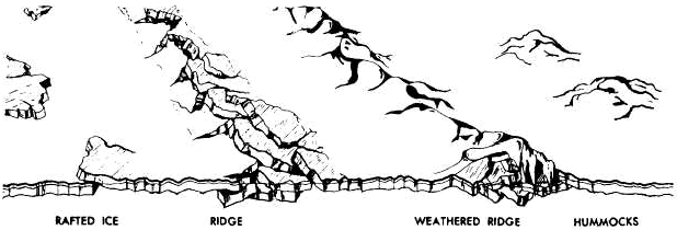
In the open sea, the first sign that the sea surface is freezing is an oily opaque appearance of water. This appearance is caused by the formation of minute ice needles (spicules) and thin plates of ice (frazil crystals). As the formation process continues, the surface attains a thick soupy consistency termed grease ice. Next, depending on the wind, waves, and salinity, an elastic or brittle crust forms. The elastic crust (nilas) has a matte appearance, while the brittle crust (ice rind) is shiny. As the crust thickens, the wind and sea cause the ice to break up into rounded masses known as pancake ice. With continued freezing, the pancake ice forms into a continuous sheet. The formation of sea ice usually begins with the onset of autumn, and the first ice usually appears in the mouths of rivers that empty into shallow seas, such as that off northern Siberia. During the increasingly longer and colder nights of autumn, ice forms along the shorelines (fast ice) and becomes a semipermanent feature that widens and spreads. When islands are close together, as in the Siberian Sea, fast ice blankets (ammanta) the sea surface, and bridges the waters between all land areas. On the average in the Northern Hemisphere, sea ice is at a minimum in September, while at a maximum in March. In the Southern Hemisphere these times are nearly opposite; minimum in March and maximum in September. SEA ICE CLASSIFICATION. —Sea ice is sub-divided into young ice, first-year ice, and old ice. Young Ice. —This ice forms in one year or less, and its thickness ranges from 10 to 30 centimeters (4 to 12 inches). It is further classified as gray ice and gray-white ice. First-year Ice. —This ice is a more or less unbroken level of ice of not more than one winter’s growth that starts as young ice. Its thickness is from 30 centimeters to 2 meters (1 foot to 6 1/2 feet). First-year ice may be subdivided into thin first-year ice, medium first-year ice, and thick first-year ice. The latter is more than 4 feet thick.Old Ice. —Old ice is extremely heavy sea ice that has survived at least one summer’s melt. It occurs primarily in the arctic and antarctic polar packs as a vast mass of converging, crushing, and dividing ice floes of various ages, sizes, shapes, and thicknesses that drift around the Arctic Basin and Antarctica. Old ice may be subdivided into second-year ice and multi-year ice. SIZE. —Generally, sea ice is categorized into seven sizes. Refer to figure 1-1-5 for relative sizes and a comparison to other more common features. TOPOGRAPHY. —The terms most frequently used to describe the topography, or configuration of the ice surface, are related to the degree of surface roughness. Figure 1-1-6 illustrates the following types of topography:  Rafted Ice. This type of topography occurs when ice cakes override one another. Rafting occurs when wind forces ice cakes or ice floes together. It is associated with young and first-year ice. Rafted Ice. This type of topography occurs when ice cakes override one another. Rafting occurs when wind forces ice cakes or ice floes together. It is associated with young and first-year ice.
Ridged Ice. Ridged ice is much rougher than rafted ice and occurs with first-year ice. Wind and weather can eventually smooth the surface of the ridges.Hummocked Ice. Hummocking occurs with old ice. It is defined as ice piled haphazardly (casualmente) into mounds (montagnole) or hillocks (collinette). At the time of its formation, hummocked ice is similar to rafted ice; the major difference being that the hummocked ice, because of its thickness, requires a greater degree of pressure and heaping (ammassamento).DRIFT. Drift refers to sea ice, as well as broken off portions (outer edges) of fast ice that move along with wind, tides, and currents. Direction. —Pack ice, sea ice covering more than half of the visible sea surface, usually drifts to the right of the true wind in the Northern Hemisphere (left in the Southern Hemisphere). Observations show that the actual drift is about 30° from that of the wind direction, or very nearly parallel to the isobars on a weather map. The drift more closely follows the wind in winter than in summer. In summer, the tides play a bigger role in the movement of the ice. Speed. —A close estimate of the speed of drifting pack ice is possible using the wind speed. On the average, the drift of ice in the Northern Hemisphere ranges from 1.4% of the wind speed in April, to 2.4% of the wind speed in September. Although wind is the primary driving force, the presence or absence of open water in the direction of the drift greatly influences the speed of drift. Ice-free water in the direction of the drift, no matter how distant, permits the pack ice to drift freely in that direction. Ice-clogged water, on the other hand, slows the ice’s forward movement. WATER FEATURES. —Naval operations in and around fields of sea ice can be hazardous. The movement of massive floes (banchi galleggianti) of ice can cut off ships from open water, and worse yet, the ice may close in around a ship, leaving it stranded (arenata) in a sea of ice. Therefore, open water in ice-covered seas becomes very important. There is a great variety of water features associated with sea ice. Some of the most common features are as follows:Fracture. Any break through the ice. Lead. A long, narrow break or passage through the ice; a navigable fracture. A lead may be open or refrozen. Puddle. A depression in sea ice usually filled with melted water caused by warm weather. Thaw holes. Holes in the ice that are caused by the melting associated with warm weather. Polynya. Any sizable area of seawater enclosed by sea ice. Put another way, simply a large hole in the ice.
|