4.1 Condensation and precipitation producing processes
LEARNING OBJECTIVES:
|
Evaluate the processes necessary for condensation and precipitation to
occur.
We will begin our discussion by identifying the conditions that must be
present for condensation and precipitation to take place
|
The temperature of a parcel of air must be lowered to its dewpoint for
condensation to occur. Condensation depends upon two variables
-
the amount of cooling
-
and the moisture content of the parcel.
Two conditions must be met for condensation to occur;
-
first, the air must be at or near saturation, and
-
second, hygroscopic nuclei must be present.
The first condition may be brought about by evaporation of additional
moisture into the air, or by the cooling of the air to its dewpoint temperature.
The first process (evaporation of moisture into the air) can occur only if the
vapor pressure of the air is less than the vapor pressure of the moisture source.
The second condition (cooling) is the principal condensation producer.
Nonadiabatic cooling processes (radiation and conduction associated with
advection) primarily result in fog, light drizzle, dew or frost.
The most effective cooling process in
the atmosphere is adiabatic lifting of air. It is the only process capable of
producing precipitation in appreciable amounts. It is also a principal producer
of clouds, fog, and drizzle. The meteorological processes that result in
vertical motion of air are discussed in the following texts. None of the cooling
processes are capable of producing condensation by themselves; moisture in the
form of water vapor must be present.
Precipitation occurs when the products of condensation and/or sublimation
coalesce to form hydrometers that are too heavy to be supported by the upward
motion of the air. A large and continuously replenished supply of water droplets,
ice crystals, or both is necessary if appreciable amounts of precipitation are
to occur.
Adiabatic lifting of air is accomplished by orographic lifting, frontal lifting,
or vertical stretching (or horizontal convergence). All of these mechanisms are
the indirect results of horizontal motion of air.
Orographic lifting is the most
effective and intensive of all cooling processes. Horizontal motion is
converted into vertical motion in proportion to the slope of the inclined
surface. Comparatively flat terrain can have a slope of as much as 1 mile in 20
miles. The greatest extremes in rainfall amount and intensity occur at mountain
stations. For this reason, it is very important that the forecaster be aware of
this potential situation.
Frontal lifting is the term applied to the process represented on a front
when the inclined surface represents the boundary between two air masses of
different densities. In this case, however, the slope ranges from 1/20 to 1/100
or even less. The steeper the front, the more adverse and intense its effects,
other factors being equal. These effects were discussed in detail in the AG2
TRAMAN, volume 1.
Since it is primarily from properties of the horizontal wind field that
vertical stretching is detectable, it is more properly called convergence.
This term will be used hereafter.
The examples of convergence and divergence, explained in the foregoing, are
definite and clear cut, associated as they are with the centers of closed flow
patterns. Less easily detected types of convergence and divergence are
associated with curved, wave-shaped, or straight flow patterns, where the air is
moving in the same general direction. Variations in convergence and divergence
are indicated in figures 4-1, 4-2, 4-3, and 4-4 by means of the following key:
The left side of figure 4-1 illustrates longitudinal convergence and
divergence; the right side illustrates lateral convergence and divergence. Many
more complicated situations can be analyzed by separation into these components.
It can be shown mathematically and verified synoptically that a fairly deep
layer of air moving with a north-south component has associated convergence or
divergence, depending on its path of movement. In figure 4-2 the arrows indicate
paths of meridional flow in the Northern Hemisphere. In
general, equatorward flow is divergent unless turning cyclonically, and poleward
flow is convergent unless turning anticyclonically.
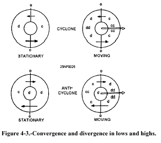 The four diagrams of figure 4-3 represent the approximate distribution of
convergence and divergence in Northern Hemispheric cyclones and anticyclones.
For moving centers, the greatest convergence or divergence occurs on or near the
axis along which the system is moving. The diagrams of figure 4-3 show eastward
movement, but they apply regardless of the direction of movement of the center.
The four diagrams of figure 4-3 represent the approximate distribution of
convergence and divergence in Northern Hemispheric cyclones and anticyclones.
For moving centers, the greatest convergence or divergence occurs on or near the
axis along which the system is moving. The diagrams of figure 4-3 show eastward
movement, but they apply regardless of the direction of movement of the center.
Convergence and divergence are not quite so easily identified in wave-shaped
flow patterns because the wave speed of movement is often the factor that
determines the distribution. The most common distribution for waves moving
toward the east is illustrated in figure 4-4. 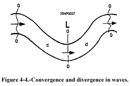 There is relatively little
divergence at the trough and ridge lines, with convergence to the west and
divergence to the east of the trough lines. There is relatively little
divergence at the trough and ridge lines, with convergence to the west and
divergence to the east of the trough lines.
This chapter devotes more time to a discussion of convergence because it is the
most difficult characteristic to assess. Its extent ranges from the extremely
local convergence of thunderstorm cells and tornadoes to the large-scale
convergence of the broad and deep currents of poleward- and equatorward-moving
air masses.
The amount, type, and intensity of the weather phenomena resulting from any of
the lifting processes described in this chapter depend on the stability or
convective stability of the air being lifted.
All of the lifting mechanisms (orographic, frontal, vertical stretching) can
occur in any particular weather situation. Any combination, or all three, are
possible, and even probable. For instance, an occluded cyclone of maritime
origin moving onto a mountainous west coast of a continent could easily have
associated with it warm frontal lifting, cold frontal lifting, orographic
lifting, lateral convergence, and convergence in the southerly flow. All fronts
have a degree of convergence associated with them.
|